
Bukit Timah is a green, high‑end planning area, part of the Central Region of Singapore known for its exclusivity. It is perhaps the only district in Singapore still dominated by landed homes and luxury condominiums, with only small pockets of HDB flats on the outskirts, at Toh Yi Drive and Farrer Road. Despite their names, Bukit Timah Nature Reserve, home to Singapore’s highest natural point, Bukit Timah Hill, are actually arguably part of neighbouring Bukit Panjang.
Read Also: Neighbourhood Estate Guide: Rediscovering Jurong East, The Regional Centre Of The West
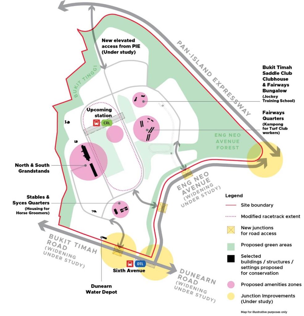
Plans are already underway to transform the district with the Bukit Timah Turf City redevelopment. Built on the former home of Singapore’s second racecourse in the heart of Bukit Timah, the new Bukit Timah Turf City will add 15,000 to 20,000 public and private homes, including the first HDB flats in Bukit Timah in nearly 40 years. These will be built around a new MRT station, Turf City, on the upcoming Cross Island Line, which is targeted for completion in 2032. This will undoubtedly reshape the estate’s housing mix and accessibility while retaining its green character.
A Brief History of Bukit Timah
The name “Bukit Timah” literally means “Tin Hill” in Malay, despite the area having no connection to tin mining. It’s possible that early cartographers likely confused timah (tin) with tema (a local tree), and the name endured. The hill itself, rising to about 163.6 metres, is Singapore’s highest natural point and has long been a landmark for travellers moving between the central region of Singapore and the rural north.
What we know as the Bukit Timah district today was built around Bukit Timah Road, which was completed in the early 1840s and became one of Singapore’s earliest major thoroughfares. Home to the third-oldest Chinese-speaking Presbyterian congregation in Singapore, Glory Presbyterian Church established what we know today as Pei Hwa Presbyterian School in 1889. Pioneering Hokkien philanthropist and businessman Tan Kah Kee raised funds to establish the Chinese High School in 1919, moving it to its current location along Bukit Timah Road in 1925, where it is known today as Hwa Chong Institution. Raffles College, the predecessor of the National University of Singapore (NUS), was founded in Bukit Timah in 1929. The Singapore Nanyang Girls’ School moved to King’s Road in 1931.
A Historically Distinguished Education Cluster
Following World War II, Bukit Timah evolved further into a residential district prized for its greenery and proximity to top schools. Bukit Timah became the home of institutions such as Anglo-Chinese School in the 50s, St. Margaret’s Secondary School in the 60s, Methodist Girls’ School and Raffles Girls’ Primary School in the 90s. Singapore’s first junior college, National Junior College was also established in Bukit Timah in 1969, as Bukit Timah was considered to be a central location convenient for all students. The Raffles College building later became home to the newly established Singapore Management University in 2000.
Good Class Bungalow areas were gazetted here, cementing its reputation as one of Singapore’s most exclusive addresses. The Singapore Turf Club relocated to Bukit Timah in 1933, becoming a social hub for horse racing until its closure in 1999. Its grounds are now the focus of URA’s Turf City redevelopment.
Bukit Timah Today – Transport and Connectivity
Bukit Timah feels distinctly low‑rise and residential. It is home to about one third of the 39 officially gazetted Good Class Bungalow enclaves, including Leedon Park and Swiss Club Road. Clusters of luxury condominiums also dominate the landscape, including the upcoming Watten House and Giverny Residences. Public housing is limited, with small pockets such as Toh Yi Drive and Queen’s Road.
Since 2015, Bukit Timah is served by the Downtown Line, with MRT stations at Beauty World, King Albert Park, Sixth Avenue and Tan Kah Kee. This complements the Circle Line stations of Botanic Gardens, Farrer Road and Holland Village, which opened about four years prior in 2011. Looking ahead, the future Cross Island Line’s Turf City station, targeted for 2032, will significantly improve accessibility. The Cross Island Line and the Downtown Line will intersect at King Albert Park station.
Read Also: Which Housing Estates Will Benefit The Most From The Cross Island Line (CRL)?
Road connectivity is strong via the parallel thoroughfares of Bukit Timah Road and Dunearn Road, though traffic is notoriously heavy during peak hours.
The Future Of Turf City
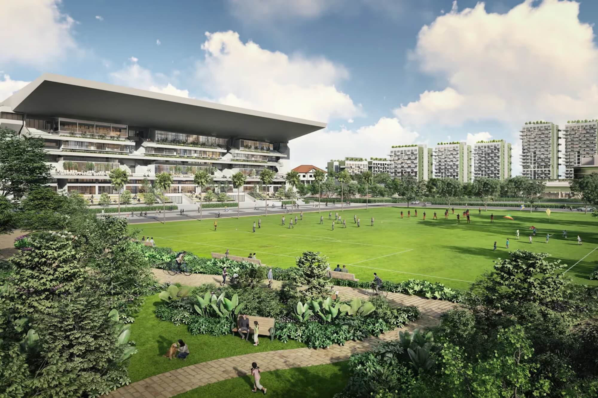
The Bukit Timah Turf City masterplan is the single biggest change on the horizon. URA envisions an inclusive, car‑lite estate with 15,000 to 20,000 homes, neighbourhood parks and conserved heritage buildings, served by two MRT stations.
Source: URA
Development will be staged over decades, with phased construction, road upgrades and new amenities. For the first time in four decades, Bukit Timah will see new HDB flats, broadening accessibility while retaining its green corridors.
Read Also: 6 Types Of Spaces That Are Making Way For New HDB Flats
Details are relatively sparse right now, but we have been assured that plans were shaped through consultations with residents, youth, nature groups, and heritage advocates.
The estate will feature inclusive housing options, community nodes, and amenities designed to serve both existing and future residents. These include retail and F&B outlets, sports facilities, schools, healthcare services, and spaces for seniors. The two conserved grandstands will be rejuvenated as community hubs, anchoring the estate’s identity while marking its equestrian heritage.
URA’s plan emphasises conserving both biodiversity and heritage. Environmental studies identified habitats and species of high ecological value, which will be retained to preserve connectivity across green corridors. Heritage studies proposed conserving 22 buildings, including the two grandstands and the Dunearn Water Depot, an art deco structure built in 1952.
These conserved sites will be adaptively reused as community spaces, blending history with modern living. The redevelopment thus aims to create a sustainable, inclusive estate that respects Bukit Timah’s natural and cultural legacy while meeting Singapore’s long‑term housing needs.
Read Also: 5 Brownfield Sites That The Singapore Government Is Redeveloping


Bonds and Fixed Income
StashAway Income Portfolio: How You Can Earn 4.6%* Dividends From Your Investments Each Year


